How it works...
Master—Auxiliary Corrections
The Method
In the Master Auxiliary Concept the Network RTK server sends full raw observations and coordinate information for a single reference station, the Master Station. For all other stations in the network (or a suitable subset of stations), known as auxiliary stations, their ambiguity reduced observations and coordinate differences (to the Master Station observations and coordinates) are transmitted.
The relationship between the server and the rover is shown in Figure 5.
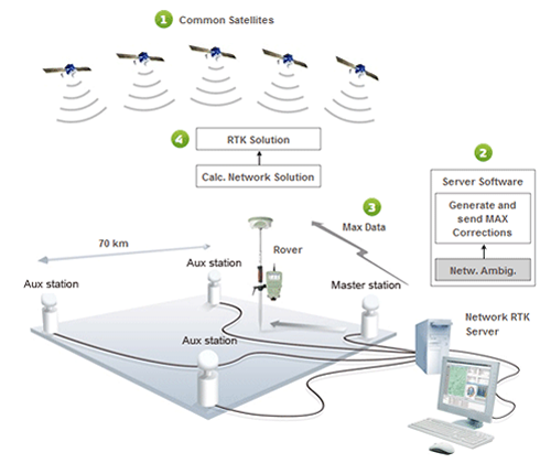
The relationship between the server and the rover
using the Master-Auxiliary Concept method
Standardized method
MAX uses published algorithms to generate and send Network RTK corrections and is therefore a standardized method. In addition, the data is always traceable to real reference stations.
The RTCM Special Committee 104 has acknowledged this by making MAX the only official standard for Network RTK by including it in the RTCM 3.1 standards document.
Rover-controlled Network solution
The Master Auxiliary Concept gives the rover the flexibility to perform either a simple interpolation of the network corrections like FKP, or a more rigorous calculation (e.g. calculate multiple baselines from the auxiliary reference stations). This means the rover can monitor the RTK solution and change its calculation on-the-fly to optimize the RTK solution. This is a major advantage over FKP and any other method.
Maximizes use of all satellite data
With these MAX data the rover can reconstruct the ambiguity-reduced data of every reference station. Therefore, maximizing the use of all satellite data to calculate the best possible RTK solution.
Consistency
The rover has the possibility to adapt to the prevailing atmospheric conditions by using an appropriate number of reference stations (e.g. to model larger scale atmospheric activity). This means the rover can ensure that the RTK solutions (positions and accuracies) are consistent throughout a survey.
Traceable and Repeatable
The MAX corrections allow the rover to measure a baseline to the master station – a real reference station. Therefore, the measurements are traceable and repeatable (Fig 6).