How it works...
Example — Using Network RTK
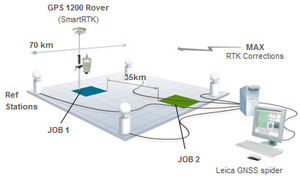
In this example there are two surveyors, Surveyor A and Surveyor B. Both surveyors have the same two jobs to complete, Job 1 and Job 2. Each job takes 30 minutes to walk around all the required points. The jobs are spaced 35 km apart.
Surveyor A
Surveyor A
Surveyor A is using a Network RTK capable GNSS Rover to receive RTK corrections from SmartNet. Surveyor A takes the following steps to complete Job 1 (Fig. 4):
- Drive to Job.
- Setup the rover.
- Connect to SmartNet to receive RTK corrections.
- Walk around and measure points.
- Disconnect from SmartNet.
- Pack up rover.
Figure 4: Surveyor A completing Job 1
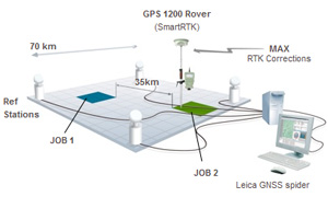
Figure 5: Surveyor A completing Job 2
Surveyor B
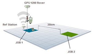
Surveyor B is using a base station and rover either with either a traditional RTK radio setup or a pair with cellular data devices providing the communication link. Surveyor B takes the following steps to complete Job 1 (Fig. 6):
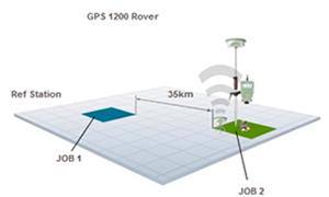
Surveyor B could also choose to leave the base station setup at Job 1 and carry on to Job 2 (Fig. 8).
In this case, by increasing the distance between the rover and the reference to 35 km, there would be an associated decrease in accuracy of the rovers computed position. Therefore, Surveyor B would be sacrificing accuracy in favor of saving time on the setting up of the base station. Surveyor B would also have the additional step of collecting the base station before returning to work.
- Drive to Job.
- Setup base station in a suitable location, which may or may not be adjacent to the working area.
- Measure height of base station.
- Start the base station broadcasting RTK corrections.
- Go to the start of the job.
- Setup the rover.
- Connect rover to the base station to receiver RTK corrections.
- Walk around and measure points.
- Pack up rover.
- Return to the base station.
- Re-measure height of base station (to check that it has not moved).
- Pack up base station.
Surveyor B could also choose to leave the base station setup at Job 1 and carry on to Job 2 (Fig. 8).
In this case, by increasing the distance between the rover and the reference to 35 km, there would be an associated decrease in accuracy of the rovers computed position. Therefore, Surveyor B would be sacrificing accuracy in favor of saving time on the setting up of the base station. Surveyor B would also have the additional step of collecting the base station before returning to work.
Figure 6: Surveyor B completing Job 1
Figure 7: Surveyor B completing Job 2
Summary
By not needing to setup a base station, Surveyor A had a lot less work to do in the field than Surveyor B. In addition, Surveyor A avoided potential risks such as:
In contrast, by using SmartNet, Surveyor A could achieve consistent accuracy for both jobs, as well as dramatically increased his productivity. No sacrifices were made.
- The base station battery going dead.
- The base station radio battery going dead.
- The base station being moved (e.g. cattle, wind, traffic or thieves!).
In contrast, by using SmartNet, Surveyor A could achieve consistent accuracy for both jobs, as well as dramatically increased his productivity. No sacrifices were made.
OUR SERVICES
APPLICATIONS
EXPLORE FEATURES