How it works...
Single Reference Station RTK
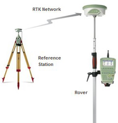
RTK rovers traditionally receive RTK data from a single RTK reference station. The reference station may be permanently setup (e.g. on the roof of the office) or it might be temporarily set up in the field. In both cases the principle is the same.
The Principle
The Principle
The principle of Single Reference RTK begins with a single reference station that is:
- Setup up on a known point; and
- Sending corrections to the rover via a communication link (normally a one-way radio modem or GSM connection) (Fig. 2).
- Both the reference and rover are observing a common set of satellites.
- The reference sends all its position and satellite observations to the rover.
- The rover combines these reference station observations with its own observations to compute an RTK position.
Figure 2: Principle of single baseline RTK
Advantages of Single Station RTK
Disadvantages of Single Station RTK
- The principle is relatively straightforward and generally well understood.
- Traceability can be maintained through the reference station being setup on a known point and the rover managing all the position calculations.
- The cost to purchase the reference station.
- The time needed to setup the reference station.
- As the distance increases between the reference and the rover the accuracy of the rovers computed position decreases.
This decrease in accuracy is due to distance dependent errors – mainly atmospheric errors. Essentially, as the distance between the rover and the reference station increases, the atmospheric conditions at the rover and reference station will become increasingly different. This decreases the accuracy and makes it more difficult for the rover to fix the ambiguities.
OUR SERVICES
APPLICATIONS
EXPLORE FEATURES